Officials mapping out Dixie Highway
Jennifer Maddox Parks
ALBANY, Ga. — Before the state highway system evolved, there was the Dixie Highway, which is said to have had a profound impact on the eastern and midwestern United States, prompting officials to enter into an in-depth research project to learn more about its history, geography and roadside culture.
As part of the research, an open house was conducted at the Albany Welcome Center Monday afternoon to allow members of the public to provide whatever photos or memorabilia they had of the roadway system to help aid the project.
The Georgia Historical Society is partnering with the Georgia Department of Transportation and the Federal Highway Administration for the study. The project will look at the cultural and historical impact of the cities and towns the road passed through, officials say.
“We are looking at that time period and what (the roadway) meant to Southerners,” said Mary Beth Reed, project manager for the Dixie Highway context text study. “We are interested in learning where it is to create a model for a resource study.
“(The Dixie Highway existed) during a time that we came to think of roads in a different way.”
State archives and public libraries, along with public input, have helped put the pieces together. Once the geography of the road has been established, surveys will be conducted beginning in January to see how much of the roadway has been preserved so that the information can be used for future project planning, Reed said.
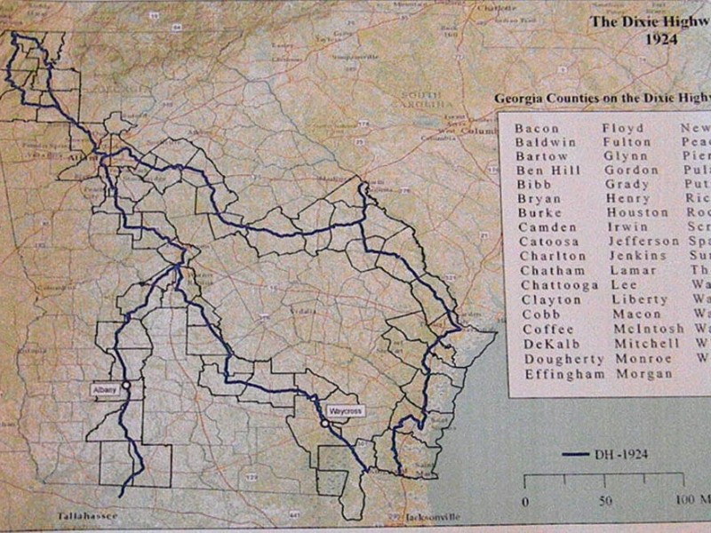
The Dixie Highway, which extended from Michigan to Florida, was first planned in 1914 to connect the Midwest with the southern United States. It was built in response to the growing number of motorists in the early 20th century and had a vital impact on the tourism industry in that region of the country, researchers say.
“The Georgia Historical Society is excited to be partnering with the Georgia Department of Transportation on this project as it provides us with an opportunity to highlight the importance of transportation networks in our state and broaden our collection resources on the Dixie Highway,” said GHS President and CEO Todd Groce in a news release earlier this month.
The roadway, while officially known only as the Dixie Highway through the late 1920s, was still commonly referred to by that name into the 1950s before it was instilled into modern highways, researchers say.
In Albany, the Dixie Highway once sat in the area that is now Jefferson Street and goes onto West Broad Avenue and to Radium Springs Road. From there, it extended into Thomasville and through Tallahassee, Fla.
This put Dougherty County in what was the western division of the roadway in Georgia, researchers say.
Albany was one of seven locations in Georgia along the former Dixie Highway’s route researchers were planning to visit through Nov. 8. Another open house is planned to take place in Waycross today.
Researchers say the project is being funded by GDOT.
Related Articles

Brie’s Gift offers a helping hand for families affected by leukemia
“I think that would be beautiful. Brie loved her school, she loved her city. I think that would be wonderful.”

Classifieds – June 30, 2026
JOBS: Full-Time – Fire Fighting Pilot for Thrush Aircraft, LLC… SERVICE … DIRECTORY: Health – Private Caregiver… Home Repair/Remodeling: Enhanced Remodeling & Drywall…
Albany Herald – June 30, 2026
Albany Commission approves $358.2
million budget… State Bar of Georgia honors Willie Lockette with… Red light violations will bring citations at…